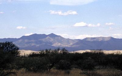
Imagine a scene right out of a western movie, a broad valley of grass and trees with rugged mountains on either side. Not a road or house to be seen, as if nothing has changed for hundreds of years. No wonder several western movies have been filmed here and thanks to recent legislation passed by congress the site will always remain as it is now.
Previously known as Empire Ranch the area is now Las Cienegas National Conservation Area, administered by the BLM the area is available for public access. This vast stretch of land can be used for camping and riding and is popular with birders for the many species that can be found in the area.
During the winter the sky here can be spectacular, but do come prepared for cold. Temperatures in the twenties (°F) are normal on winter nights due to the higher elevation and the surrounding mountains make for cold night breezes.
The observing site is an abandoned and somewhat overgrown airstrip (see map below). This offers ample room for as many telescopes as any club can field. The airstrip parallels the main road, but is far enough off that the headlights of any traffic are not a problem. Most people set up at least half way down the airstrip to avoid any other traffic. Las Cienegas is a great place to arrive before sundown, set up your equipment, relax and watch the sun set and the sky grow dark.